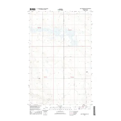
2017 Map of Lake Thibadeau SW
USGS Topo · Published 2017About this map
Mud Lake dominates the upper reaches of this northern Montana landscape in Hill County, where the plains are defined by seasonal water and the slow-moving drainage of the high prairies. This 2017 survey shows a region largely dedicated to open range and agriculture, delineated by a rigid grid of rural corridors such as Saint Joe Rd and Rd 475 N. The terrain is interrupted by the winding paths of Staton Coulee and Lohman Coulee, which serve as natural landmarks and drainage channels in a place where water movement dictates land use. These features provide a clear picture of the modern township and range system, showing the placement of private access routes like Pvt Field Rd alongside established public county lines.
Find a feature on this map
16 named features on this map. Tap any name to fly to it.
Don’t see what you’re looking for? This feature index may not catch every label — zoom into the map to look around manually.
Map Details
Editions of this 2017 Lake Thibadeau SW Map
This is the sole edition of this map. No revisions or reprints were ever made.
Other maps of this area

1904 · Havre
USGS Topo · 1:62,500

1904 · Assinniboine
USGS Topo · 1:62,500

1912 · Thibedeau Lake
USGS Topo · 1:125,000

1953 · Havre
USGS Topo · 1:250,000

1957 · Havre
USGS Topo · 1:250,000

1958 · Havre
USGS Topo · 1:250,000

1964 · Havre NW
USGS Topo · 1:24,000
1964 · Havre NE
USGS Topo · 1:24,000
1970 · Quigley Coulee
USGS Topo · 1:24,000

1972 · Hilldale Colony
USGS Topo · 1:24,000