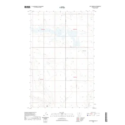
2020 Map of Lake Thibadeau SW
USGS Topo · Published 2020About this map
Mud Lake occupies the center of this north-central Montana landscape, forming a significant wetland basin within the high plains of Hill County. The surrounding terrain is defined by the subtle drainage patterns of Lohman Coulee to the east and Staton Coulee at the southern margin, illustrating the erosional character of the prairie. A grid of rural section roads, including Saint Joe Rd and Rd 210 N, organizes the wide-open ranching and agricultural tracts that dominate the township. These surveyor lines and field access points, such as Pvt Field Rd, provide a clear view of how land use and property boundaries were established across the townships of T36N R15E and T35N R16E during the modern era.
Find a feature on this map
15 named features on this map. Tap any name to fly to it.
Don’t see what you’re looking for? This feature index may not catch every label — zoom into the map to look around manually.
Map Details
Editions of this 2020 Lake Thibadeau SW Map
This is the sole edition of this map. No revisions or reprints were ever made.
Other maps of this area

1904 · Havre
USGS Topo · 1:62,500

1904 · Assinniboine
USGS Topo · 1:62,500

1912 · Thibedeau Lake
USGS Topo · 1:125,000

1953 · Havre
USGS Topo · 1:250,000

1957 · Havre
USGS Topo · 1:250,000

1958 · Havre
USGS Topo · 1:250,000

1964 · Havre NW
USGS Topo · 1:24,000
1964 · Havre NE
USGS Topo · 1:24,000
1970 · Quigley Coulee
USGS Topo · 1:24,000

1972 · Hilldale Colony
USGS Topo · 1:24,000