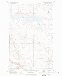
1972 Map of Lake Thibadeau SW
USGS Topo · Published 1975About this map
Lake Thibadeau National Wildlife Refuge anchors the eastern edge of this northern Montana landscape, where the prairie is defined by a series of deep drainages and seasonal water bodies. The hydrology of the region is centered on the bifurcated Mud Lake, which is fed by the winding course of Willow Creek. This 1972 field-checked survey reveals a sparsely populated agricultural and conservation area where land use is dictated by the rugged coulees. Local transportation and utility are marked by St Joe Road and a solitary Landing Strip in the southern section. The presence of named geographic features like Lohman Coulee and Staton Coulee provides essential markers for land ownership and cattle movement across the open range typical of Hill County during the early 1970s.
Find a feature on this map
8 named features on this map. Tap any name to fly to it.
Don’t see what you’re looking for? This feature index may not catch every label — zoom into the map to look around manually.
Map Details
Editions of this 1972 Lake Thibadeau SW Map
This is the sole edition of this map. No revisions or reprints were ever made.
Other maps of this area

1904 · Havre
USGS Topo · 1:62,500

1904 · Assinniboine
USGS Topo · 1:62,500

1912 · Thibedeau Lake
USGS Topo · 1:125,000

1953 · Havre
USGS Topo · 1:250,000

1957 · Havre
USGS Topo · 1:250,000

1958 · Havre
USGS Topo · 1:250,000

1964 · Havre NW
USGS Topo · 1:24,000
1964 · Havre NE
USGS Topo · 1:24,000
1970 · Quigley Coulee
USGS Topo · 1:24,000

1972 · Hilldale Colony
USGS Topo · 1:24,000