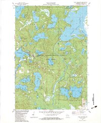
1982 Map of Lake Tomahawk
USGS Topo · Published 1983About this map
The community of Lake Tomahawk serves as a central hub within this 1980s landscape, positioned along the shores of Tomahawk Lake. This region is defined by the extensive Northern Highland-American Legion State Forest, where a dense network of water bodies like Clear Lake, Gilmore Lake, and Hasbrook Lake dominates the terrain. The presence of the Three Little Lakes Lake Tomahawk Lookout Tower and the Dolhun Airstrip reflects the area's development for both resource management and seasonal access.
Find a feature on this map
63 named features on this map. Tap any name to fly to it.
Don’t see what you’re looking for? This feature index may not catch every label — zoom into the map to look around manually.
Map Details
Editions of this 1982 Lake Tomahawk Map
This is the sole edition of this map. No revisions or reprints were ever made.
Other maps of this area

1930 · Robbins
USGS Topo · 1:48,000

1938 · Minocqua
USGS Topo · 1:48,000

1938 · Robbins
USGS Topo · 1:48,000

1939 · Cassian
USGS Topo · 1:48,000

1940 · Rhinelander
USGS Topo · 1:48,000

1942 · Cassian
USGS Topo · 1:48,000

1945 · Robbins
USGS Topo · 1:48,000

1946 · Minocqua
USGS Topo · 1:48,000

1949 · Rhinelander
USGS Topo · 1:48,000

1949 · Minocqua
USGS Topo · 1:48,000