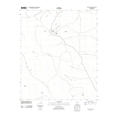
2010 Map of Lake Valley
USGS Topo · Published 2010About this map
The silver mining legacy of Sierra County is etched across this landscape at Lake Valley, where the density of mineral workings remains a central geographical feature. This area was once home to one of the most famous silver strikes in the West, and this survey documents the industrial footprint of operations like the Sierra Grande Mine, Sierra Bella, and the legendary Bridal Chamber Mine. These sites are concentrated around Apache Hill and Town Mountain, north of the main settlement. The surrounding terrain is a network of dry watercourses, including Ricketson Draw and Abernathy Draw, which carve through the high desert floor toward Macho Creek. Beyond the mining district, the land is defined by ranching life, with scattered homesteads such as McGregor Ranch, Franks Ranch, and Phillips Ranch situated along the county road system. In the southern reach of the quadrangle near Round Mountain, evidence of earlier prospecting continues at the Dude Mine and Old Dude settlement.
Find a feature on this map
35 named features on this map. Tap any name to fly to it.
Don’t see what you’re looking for? This feature index may not catch every label — zoom into the map to look around manually.
Map Details
Editions of this 2010 Lake Valley Map
This is the sole edition of this map. No revisions or reprints were ever made.
Other maps of this area

1935 · Hillsboro
USGS Topo · 1:48,000

1940 · Hillsboro
USGS Topo · 1:62,500

1955 · Las Cruces
USGS Topo · 1:250,000

1958 · Las Cruces
USGS Topo · 1:250,000

1961 · Nutt
USGS Topo · 1:62,500

1961 · Clark Spring Canyon
USGS Topo · 1:24,000

1962 · Lake Valley
USGS Topo · 1:62,500

1982 · Hatch
USGS Topo · 1:100,000
1985 · P A Mountain
USGS Topo · 1:24,000
1985 · Mc Clede Mountain
USGS Topo · 1:24,000