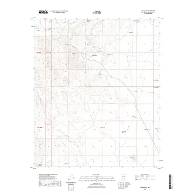
2020 Map of Lake Valley
USGS Topo · Published 2020About this map
Lake Valley sits at the center of this high-desert landscape in Sierra County, defined by a complex network of canyons and peaks that have historically shaped local movement and land use. The topography is anchored by prominent landmarks such as Town Mtn and Monument Peak, while the northern reaches are dominated by the sharp elevation of Quartzite Ridge. Water sources, though often seasonal in this environment, are mapped with precision, including Berrenda Cr in the north and the extensive drainage of Macho Creek to the south.
Find a feature on this map
44 named features on this map. Tap any name to fly to it.
Don’t see what you’re looking for? This feature index may not catch every label — zoom into the map to look around manually.
Map Details
Editions of this 2020 Lake Valley Map
This is the sole edition of this map. No revisions or reprints were ever made.
Other maps of this area

1935 · Hillsboro
USGS Topo · 1:48,000

1940 · Hillsboro
USGS Topo · 1:62,500

1955 · Las Cruces
USGS Topo · 1:250,000

1958 · Las Cruces
USGS Topo · 1:250,000

1961 · Nutt
USGS Topo · 1:62,500

1961 · Clark Spring Canyon
USGS Topo · 1:24,000

1962 · Lake Valley
USGS Topo · 1:62,500

1982 · Hatch
USGS Topo · 1:100,000
1985 · P A Mountain
USGS Topo · 1:24,000
1985 · Mc Clede Mountain
USGS Topo · 1:24,000