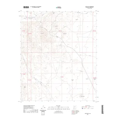
2023 Map of Lake Valley
USGS Topo · Published 2023About this map
Town Mountain and the Quartizite Ridge dominate the landscape of Sierra County, where high-desert terrain is marked by a complex system of seasonal drainages and peaks. The local history of the area is anchored by the Lake Valley Cem, a key genealogical landmark situated near Apache Hill and Monument Peak. The network of water sources, including the Macho Spring and the ephemeral flows of Berrenda Creek and Macho Creek, has long dictated the accessibility and settlement patterns of this arid region.
Find a feature on this map
40 named features on this map. Tap any name to fly to it.
Don’t see what you’re looking for? This feature index may not catch every label — zoom into the map to look around manually.
Map Details
Editions of this 2023 Lake Valley Map
This is the sole edition of this map. No revisions or reprints were ever made.
Other maps of this area

1935 · Hillsboro
USGS Topo · 1:48,000

1940 · Hillsboro
USGS Topo · 1:62,500

1955 · Las Cruces
USGS Topo · 1:250,000

1958 · Las Cruces
USGS Topo · 1:250,000

1961 · Nutt
USGS Topo · 1:62,500

1961 · Clark Spring Canyon
USGS Topo · 1:24,000

1962 · Lake Valley
USGS Topo · 1:62,500

1982 · Hatch
USGS Topo · 1:100,000
1985 · P A Mountain
USGS Topo · 1:24,000
1985 · Mc Clede Mountain
USGS Topo · 1:24,000