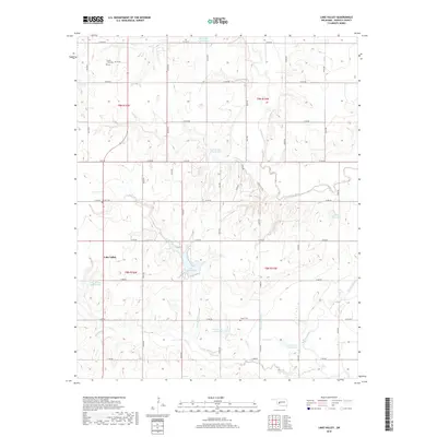
2018 Map of Lake Valley
USGS Topo · Published 2018About this map
Lake Valley and the surrounding Washita County plains are defined by an intricate network of water management and rural burial grounds. The landscape is marked by a series of engineered catchments, including Oak Cr Site 10 Reservoir and Oak Cr Site 7 Reservoir, which support the agricultural economy of this Oklahoma region. The Washita River and its western branch snake through the eastern portion of the map, joined by local drainages such as Gyp Cr and Wild Cat Cr. For genealogists, the presence of the Cloud Chief Cem, Sharon Cem, and Fesser Cem offers specific points of interest for tracing family ties in the townships of T9N R16W and T8N R15W. The area's geography is further characterized by the substantial Lake Vanderwork, providing a primary water feature amidst the grid of section roads that organize the prairie.
Find a feature on this map
43 named features on this map. Tap any name to fly to it.
Don’t see what you’re looking for? This feature index may not catch every label — zoom into the map to look around manually.
Map Details
Editions of this 2018 Lake Valley Map
This is the sole edition of this map. No revisions or reprints were ever made.
Other maps of this area

1955 · Clinton
USGS Topo · 1:250,000

1956 · Cordell
USGS Topo · 1:62,500

1957 · Clinton
USGS Topo · 1:250,000

1961 · Gotebo
USGS Topo · 1:62,500

1961 · Eakly
USGS Topo · 1:62,500

1961 · Carnegie
USGS Topo · 1:62,500
1983 · Cordell
USGS Topo · 1:24,000

1983 · Cloud Chief
USGS Topo · 1:24,000

1984 · Gotebo East
USGS Topo · 1:24,000
1984 · Colony
USGS Topo · 1:24,000