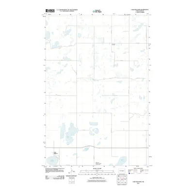
2011 Map of Lake Williams
USGS Topo · Published 2011About this map
Lake Williams sits at the southern edge of this North Dakota landscape, where the prairie is defined by a dense network of glacial potholes and small water bodies. The settlement of Lake Williams is situated on the northern shore of its namesake lake, serving as a focal point for the surrounding rural sections. The terrain is characterized by a series of larger basins including Deer Lake, Standish Lake, and Ranch Lake, which interrupt the orderly grid of section roads like 18th St SE and 45th Ave SE.
Find a feature on this map
20 named features on this map. Tap any name to fly to it.
Don’t see what you’re looking for? This feature index may not catch every label — zoom into the map to look around manually.
Map Details
Editions of this 2011 Lake Williams Map
This is the sole edition of this map. No revisions or reprints were ever made.
Other maps of this area

1952 · New Rockford
USGS Topo · 1:250,000

1956 · New Rockford
USGS Topo · 1:250,000

1971 · New Rockford
USGS Topo · 1:250,000

1972 · Kunkel Lake
USGS Topo · 1:24,000
1972 · Lake Louise
USGS Topo · 1:24,000

1972 · Lake Williams
USGS Topo · 1:24,000
1972 · Woodworth NW
USGS Topo · 1:24,000
1972 · Pettibone
USGS Topo · 1:24,000

1972 · Des Moines Lake
USGS Topo · 1:24,000

1978 · Wagon Wheel Hill
USGS Topo · 1:24,000