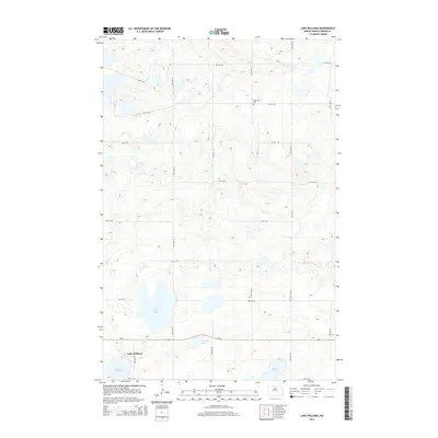
2014 Map of Lake Williams
USGS Topo · Published 2014About this map
Lake Williams sits at the heart of this Kidder County landscape, where the terrain is defined by numerous prairie potholes and glacial depressions. The settlement is positioned along Nd-36, which serves as the primary east-west corridor through this portion of North Dakota. To the north and east, the map reveals a remote pastoral character, punctuated by Petersville Cem and a series of significant water bodies including Deer Lake, Standish Lake, and Ranch Lake. The rigid grid of the Public Land Survey System is evident in the numbered section roads, such as 12th St SE and 47th Ave SE, which organize the agricultural land and connect isolated farmsteads to the village center. This 2014 survey captures a quiet, rural interior before further modernization, preserving the locations of local landmarks and water levels crucial for genealogy and land use research.
Find a feature on this map
21 named features on this map. Tap any name to fly to it.
Don’t see what you’re looking for? This feature index may not catch every label — zoom into the map to look around manually.
Map Details
Editions of this 2014 Lake Williams Map
This is the sole edition of this map. No revisions or reprints were ever made.
Other maps of this area

1952 · New Rockford
USGS Topo · 1:250,000

1956 · New Rockford
USGS Topo · 1:250,000

1971 · New Rockford
USGS Topo · 1:250,000

1972 · Kunkel Lake
USGS Topo · 1:24,000
1972 · Lake Louise
USGS Topo · 1:24,000

1972 · Lake Williams
USGS Topo · 1:24,000
1972 · Woodworth NW
USGS Topo · 1:24,000
1972 · Pettibone
USGS Topo · 1:24,000

1972 · Des Moines Lake
USGS Topo · 1:24,000

1978 · Wagon Wheel Hill
USGS Topo · 1:24,000