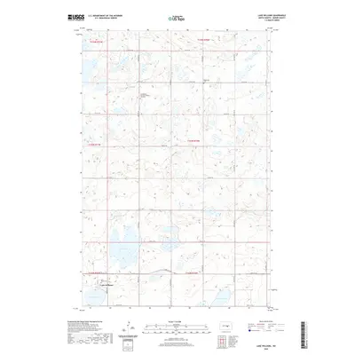
2020 Map of Lake Williams
USGS Topo · Published 2020About this map
Lake Williams sits at the southwestern edge of this Kidder County landscape, where the prairie is defined by a dense concentration of wetlands and small basins typical of the North Dakota pothole region. The settlement of Lake Williams is anchored by Saint Mary's Cem, while the surrounding rural sections preserve important genealogical markers for the local community. To the north, the Evangelical German Lutheran Zion Cem and the Petersville Cem stand as quiet evidence of early 20th-century immigrant settlement patterns. A grid of section-line roads, including 43rd Ave SE and 12th St SE, organizes the terrain around prominent water bodies like Deer Lake and Ranch Lake, illustrating how the agricultural landscape was surveyed and divided into townships and ranges.
Find a feature on this map
29 named features on this map. Tap any name to fly to it.
Don’t see what you’re looking for? This feature index may not catch every label — zoom into the map to look around manually.
Map Details
Editions of this 2020 Lake Williams Map
This is the sole edition of this map. No revisions or reprints were ever made.
Other maps of this area

1952 · New Rockford
USGS Topo · 1:250,000

1956 · New Rockford
USGS Topo · 1:250,000

1971 · New Rockford
USGS Topo · 1:250,000

1972 · Kunkel Lake
USGS Topo · 1:24,000
1972 · Lake Louise
USGS Topo · 1:24,000

1972 · Lake Williams
USGS Topo · 1:24,000
1972 · Woodworth NW
USGS Topo · 1:24,000
1972 · Pettibone
USGS Topo · 1:24,000

1972 · Des Moines Lake
USGS Topo · 1:24,000

1978 · Wagon Wheel Hill
USGS Topo · 1:24,000