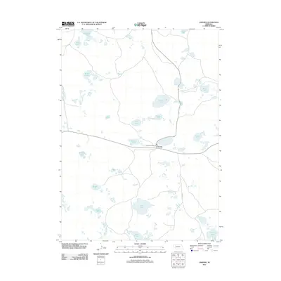
2011 Map of Lakeside
USGS Topo · Published 2011About this map
The small settlement of Lakeside serves as the primary hub in this portion of the Nebraska Sandhills, centered around the Lakeside Post Office. This landscape is defined by its numerous semi-permanent alkaline lakes and marshes, which are scattered throughout the interdunal basins. Large water bodies like Thompson Lake, Floyd Lake, and the cluster known as Patterson Lakes dominate the terrain, reflecting the unique hydrology of the High Plains. Transport in the region is concentrated along the east-west highway corridor and the north-south Lakeside Rd, which connect remote ranching interests. These labels, many likely named for early settler families such as Welsh Lake, Hancock Lake, and Ashburger Lake, provide a framework for genealogists tracing regional land use. The presence of the Chain of Lakes and Simondson Lake highlights the importance of surface water in an area where ranching remains the fundamental economic driver.
Find a feature on this map
20 named features on this map. Tap any name to fly to it.
Don’t see what you’re looking for? This feature index may not catch every label — zoom into the map to look around manually.
Map Details
Editions of this 2011 Lakeside Map
This is the sole edition of this map. No revisions or reprints were ever made.
Other maps of this area

1896 · Browns Creek
USGS Topo · 1:125,000

1899 · Browns Creek
USGS Topo · 1:125,000

1948 · Antioch
USGS Topo · 1:62,500

1948 · Lakeside
USGS Topo · 1:62,500

1949 · Mumper
USGS Topo · 1:62,500

1949 · Antioch
USGS Topo · 1:62,500

1950 · Storm Lake
USGS Topo · 1:62,500

1950 · Lakeside
USGS Topo · 1:62,500

1954 · Scottsbluff
USGS Topo · 1:250,000

1955 · Alliance
USGS Topo · 1:250,000