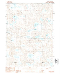
1989 Map of Lakeside
USGS Topo · Published 1989About this map
The small settlement of Lakeside serves as the focal point of this Nebraska Sandhills survey, positioned along the critical east-west corridor of the Burlington Northern railroad. The landscape is defined by a dense concentration of wetlands and water bodies, ranging from the northern Simondson Lake and Cody Lake down to the southern Floyd Lake and the Chain of Lakes. The distribution of these features across the Sheridan and Garden County line illustrates the unique hydrology of the region, where water collects in the depressions between dunes.
Find a feature on this map
22 named features on this map. Tap any name to fly to it.
Don’t see what you’re looking for? This feature index may not catch every label — zoom into the map to look around manually.
Map Details
Editions of this 1989 Lakeside Map
This is the sole edition of this map. No revisions or reprints were ever made.
Other maps of this area

1896 · Browns Creek
USGS Topo · 1:125,000

1899 · Browns Creek
USGS Topo · 1:125,000

1948 · Antioch
USGS Topo · 1:62,500

1948 · Lakeside
USGS Topo · 1:62,500

1949 · Mumper
USGS Topo · 1:62,500

1949 · Antioch
USGS Topo · 1:62,500

1950 · Storm Lake
USGS Topo · 1:62,500

1950 · Lakeside
USGS Topo · 1:62,500

1954 · Scottsbluff
USGS Topo · 1:250,000

1955 · Alliance
USGS Topo · 1:250,000