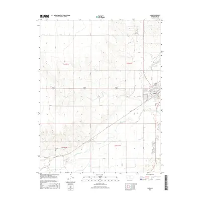
2016 Map of Lakin
USGS Topo · Published 2016About this map
Lakin serves as the central hub of this High Plains landscape, situated just north of the wide valley floor. The town's grid is bounded by W Railroad Ave and Lincoln Ave, reflecting its position within the regional transportation network. To the southwest, the settlement of Hartland sits near the riverbanks, accompanied by the Hartland Cem, providing a focal point for genealogical research in this part of Kearny County.
Find a feature on this map
43 named features on this map. Tap any name to fly to it.
Don’t see what you’re looking for? This feature index may not catch every label — zoom into the map to look around manually.
Map Details
Editions of this 2016 Lakin Map
This is the sole edition of this map. No revisions or reprints were ever made.
Other maps of this area

1891 · Larned
USGS Topo · 1:125,000

1900 · Lakin
USGS Topo · 1:125,000

1955 · Dodge City
USGS Topo · 1:250,000

1955 · Scott City
USGS Topo · 1:250,000

1958 · Dodge City
USGS Topo · 1:250,000

1958 · Scott City
USGS Topo · 1:250,000

1959 · Dodge City
USGS Topo · 1:250,000
1960 · Deerfield SW
USGS Topo · 1:24,000

1960 · Deerfield
USGS Topo · 1:24,000
1966 · Lakin SE
USGS Topo · 1:24,000