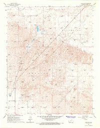
1966 Map of Lakin SE
USGS Topo · Published 1967About this map
The High Plains of Western Kansas meet industrial resource extraction in this mid-1960s study of the Kendal and Southside townships. The landscape is defined by the ephemeral path of Bear Creek and the man-made irrigation infrastructure of the Southside Ditch, which borders the northern edge of the quadrangle. This era marks a significant period of energy development for Kearny County, evidenced by the dense concentration of Gas Wells and Oil Wells scattered across the terrain.
Find a feature on this map
11 named features on this map. Tap any name to fly to it.
Don’t see what you’re looking for? This feature index may not catch every label — zoom into the map to look around manually.
Map Details
Editions of this 1966 Lakin SE Map
2 editions found
Other maps of this area

1891 · Larned
USGS Topo · 1:125,000

1900 · Lakin
USGS Topo · 1:125,000

1955 · Dodge City
USGS Topo · 1:250,000

1958 · Dodge City
USGS Topo · 1:250,000

1959 · Dodge City
USGS Topo · 1:250,000

1959 · Ulysses NW
USGS Topo · 1:24,000

1959 · Ulysses NE
USGS Topo · 1:24,000

1959 · Hickok NW
USGS Topo · 1:24,000
1960 · Deerfield SW
USGS Topo · 1:24,000

1960 · Deerfield
USGS Topo · 1:24,000