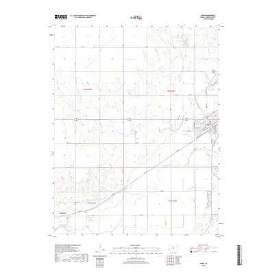
2018 Map of Lakin
USGS Topo · Published 2018About this map
The Arkansas River corridor defines the geography of this western Kansas landscape, where the settlement of Lakin serves as the seat of local activity. Agricultural irrigation patterns are clearly visible through the engineered paths of the Amazon Ditch and Southside Ditch, which parallel the river's winding course. To the southwest, the small community of Hartland sits near the Hartland Cem, a site of significant interest for those researching early regional burials and family history. The terrain is characterized by a network of rural routes, such as River Rd and Co Rd 24, that connect isolated farmsteads to the town center. The presence of Kearny County Airport and Clear Lake further mark the transition from the structured street grid of Lakin, including Kendall Ave and Santa Fe Ave, to the open prairie and valley floor of Kearny County.
Find a feature on this map
48 named features on this map. Tap any name to fly to it.
Don’t see what you’re looking for? This feature index may not catch every label — zoom into the map to look around manually.
Map Details
Editions of this 2018 Lakin Map
This is the sole edition of this map. No revisions or reprints were ever made.
Other maps of this area

1891 · Larned
USGS Topo · 1:125,000

1900 · Lakin
USGS Topo · 1:125,000

1955 · Dodge City
USGS Topo · 1:250,000

1955 · Scott City
USGS Topo · 1:250,000

1958 · Dodge City
USGS Topo · 1:250,000

1958 · Scott City
USGS Topo · 1:250,000

1959 · Dodge City
USGS Topo · 1:250,000
1960 · Deerfield SW
USGS Topo · 1:24,000

1960 · Deerfield
USGS Topo · 1:24,000
1966 · Lakin SE
USGS Topo · 1:24,000