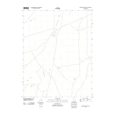
2010 Map of Lamerdorf Peak NW
USGS Topo · Published 2010About this map
Pine Valley Wash dominates this arid landscape in Beaver County, providing the primary drainage for a series of water management features in the High Desert. The management of water is central to the area's utility, evidenced by the presence of CCC Reservoir, Chamisa Reservoir, and Central Pine Reservoir. These catchments, along with the Blackburn Ditch in the southeastern portion of the quadrangle, highlight the historical and ongoing efforts to harness intermittent flows for local use. The geography is defined by broad washes, including Jackson Wash and Antelope Wash, which intersect the path of Pine Valley Rd. This road serves as the primary corridor through the terrain, connecting isolated reservoirs like Red Cove Reservoir to the wider region during the early twenty-first century.
Find a feature on this map
14 named features on this map. Tap any name to fly to it.
Don’t see what you’re looking for? This feature index may not catch every label — zoom into the map to look around manually.
Map Details
Editions of this 2010 Lamerdorf Peak NW Map
This is the sole edition of this map. No revisions or reprints were ever made.
Other maps of this area

1953 · Richfield
USGS Topo · 1:250,000

1958 · Richfield
USGS Topo · 1:250,000

1960 · Wah Wah Summit
USGS Topo · 1:62,500

1971 · Pine Grove Reservoir
USGS Topo · 1:24,000

1971 · Sewing Machine Pass
USGS Topo · 1:24,000

1971 · Halfway Summit
USGS Topo · 1:24,000

1971 · Sawtooth Peak
USGS Topo · 1:24,000

1971 · Lamerdorf Peak NW
USGS Topo · 1:24,000

1971 · Lamerdorf Peak
USGS Topo · 1:24,000
1972 · Buckhorn Spring
USGS Topo · 1:24,000