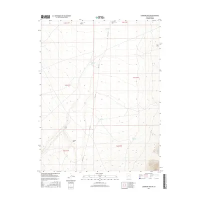
2017 Map of Lamerdorf Peak NW
USGS Topo · Published 2017About this map
Pine Valley serves as the central geographic focus of this western Utah survey, where the management of water resources in an arid environment is clearly visible. The landscape is defined by its drainages, including Jackson Wash and Turkey Wash, which converge toward the valley floor. Human intervention in the local hydrology is evident through a series of catchments and engineering projects like the CCC Reservoir, Central Pine Reservoir, and Chamisa Reservoir. These features, along with the Blackburn Ditch and Red Cove Reservoir further south, indicate a long history of water collection for livestock or agricultural use. The area is intersected by Pine Valley Rd, providing the primary transit route through this remote section of Beaver County. The map provides a look at the township and range survey system, showing how the land was subdivided into sections for administration and use.
Find a feature on this map
17 named features on this map. Tap any name to fly to it.
Don’t see what you’re looking for? This feature index may not catch every label — zoom into the map to look around manually.
Map Details
Editions of this 2017 Lamerdorf Peak NW Map
This is the sole edition of this map. No revisions or reprints were ever made.
Other maps of this area

1953 · Richfield
USGS Topo · 1:250,000

1958 · Richfield
USGS Topo · 1:250,000

1960 · Wah Wah Summit
USGS Topo · 1:62,500

1971 · Pine Grove Reservoir
USGS Topo · 1:24,000

1971 · Sewing Machine Pass
USGS Topo · 1:24,000

1971 · Halfway Summit
USGS Topo · 1:24,000

1971 · Sawtooth Peak
USGS Topo · 1:24,000

1971 · Lamerdorf Peak NW
USGS Topo · 1:24,000

1971 · Lamerdorf Peak
USGS Topo · 1:24,000
1972 · Buckhorn Spring
USGS Topo · 1:24,000