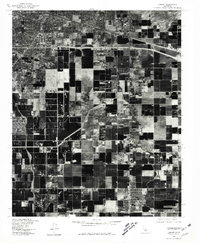
1978 Map of Lamont
USGS Topo · Published 1981About this map
Agricultural development and industrial expansion characterize this San Joaquin Valley landscape south of Bakersfield. Based on aerial photography from late 1978, this orthophotograph captures the intricate geometry of the Kern County farming grid, where massive fields are divided by irrigation canals and access roads. The settlement of Lamont serves as a central hub for the surrounding orchard and crop operations, while the community of Fuller Acres sits just to the west. The northeastern corner of the map shows the transition into the rail-served industrial district of Magunden, where transportation corridors merge with the growing outskirts of the city. The contrast between the dense residential blocks in the north and the vast, productive acreage of the valley floor reveals the economic engine of the region during the late seventies.
Find a feature on this map
4 named features on this map. Tap any name to fly to it.
Don’t see what you’re looking for? This feature index may not catch every label — zoom into the map to look around manually.
Map Details
Editions of this 1978 Lamont Map
This is the sole edition of this map. No revisions or reprints were ever made.
Other maps of this area

1906 · Bakersfield
USGS Topo · 1:62,500

1910 · Buena Vista Lake
USGS Topo · 1:125,000

1912 · Buena Vista Lake
USGS Topo · 1:125,000

1914 · Caliente
USGS Topo · 1:125,000

1929 · Fairfax School
USGS Topo · 1:31,680

1930 · Weed Patch
USGS Topo · 1:31,680

1930 · Arvin
USGS Topo · 1:31,680

1930 · Conner
USGS Topo · 1:31,680

1930 · Oildale
USGS Topo · 1:31,680

1931 · Edison
USGS Topo · 1:31,680