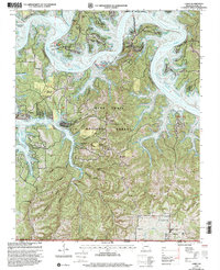
1999 Map of Lampe
USGS Topo · Published 2002About this map
Table Rock Lake and the White River dominate this Ozark landscape, where the rising waters of the mid-20th century transformed the winding river valley into a complex network of deep coves and peninsulas. Located along the Missouri-Arkansas border, the terrain is defined by its dramatic relief, including prominent peaks like Naked Joe Bald and Bread Tray Mountain. The Mark Twain National Forest blankets much of the high ground, while the lake shores are marked by recreational development at the Joe Bald Campground and Mill Creek Campground. Within this rugged topography, rural community life centers on Old Elm Tree Ch and several family burial grounds, including the Rice Cem and Pine Creek Cem, which remain as markers of the area's upland settlement history prior to the lake's creation.
Find a feature on this map
55 named features on this map. Tap any name to fly to it.
Don’t see what you’re looking for? This feature index may not catch every label — zoom into the map to look around manually.
Map Details
Editions of this 1999 Lampe Map
This is the sole edition of this map. No revisions or reprints were ever made.
Other maps of this area

1900 · Eureka Springs
USGS Topo · 1:125,000

1901 · Eureka Springs
USGS Topo · 1:125,000

1904 · Harrison
USGS Topo · 1:125,000

1905 · Harrison
USGS Topo · 1:125,000

1907 · Forsyth
USGS Topo · 1:125,000

1927 · Shell Knob
USGS Topo · 1:62,500

1945 · Harrison
USGS Topo · 1:250,000

1949 · Harrison
USGS Topo · 1:250,000

1950 · Shell Knob
USGS Topo · 1:62,500

1950 · Garber
USGS Topo · 1:24,000