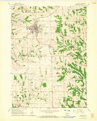
1962 Map of Lancaster
USGS Topo · Published 1964About this map
Lancaster serves as the central hub of this Grant County survey, appearing as a well-defined grid of streets and civic infrastructure during the early 1960s. The town's economic and social reach is evident in the presence of the Chicago and North Western railroad and institutions like the County Hospital and Fairground. To the south and east, the landscape transitions into the distinctive drainage basins of Pigeon Creek and the Platte River, where small rural communities and family-named landmarks are scattered among the ridges.
Find a feature on this map
43 named features on this map. Tap any name to fly to it.
Don’t see what you’re looking for? This feature index may not catch every label — zoom into the map to look around manually.
Map Details
Editions of this 1962 Lancaster Map
This is the sole edition of this map. No revisions or reprints were ever made.
Other maps of this area

1900 · Lancaster
USGS Topo · 1:125,000

1904 · Lancaster
USGS Topo · 1:125,000

1908 · Lancaster
USGS Topo · 1:125,000

1955 · Balltown
USGS Topo · 1:24,000

1957 · Potosi
USGS Topo · 1:24,000

1959 · Dubuque
USGS Topo · 1:250,000

1961 · Dubuque
USGS Topo · 1:250,000
1961 · Dickeyville
USGS Topo · 1:24,000

1962 · Dubuque
USGS Topo · 1:250,000
1962 · Mount Hope
USGS Topo · 1:24,000