
1957 Map of Potosi
USGS Topo · Published 1967About this map
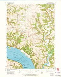
Deeply incised valleys and the broad basin of the Mississippi River define this 1957 survey of the Driftless Area. The twin communities of Potosi and Tennyson anchor the upland ridges, connected to the riverfront by a series of steep drainages like Hog Hollow and Rigsby Hollow. The river economy is clearly visible along the shore, where the Chicago Burlington and Quincy railroad skirts the base of the bluffs near Potosi (Station).
Find a feature on this map
37 named features on this map. Tap any name to fly to it.
Don’t see what you’re looking for? This feature index may not catch every label — zoom into the map to look around manually.
Map Details
Editions of this 1957 Potosi Map
2 editions found
Other maps of this area

1900 · Lancaster
USGS Topo · 1:125,000

1904 · Lancaster
USGS Topo · 1:125,000

1908 · Lancaster
USGS Topo · 1:125,000

1955 · Balltown
USGS Topo · 1:24,000

1956 · Dubuque North
USGS Topo · 1:24,000

1956 · Sherrill
USGS Topo · 1:24,000

1959 · Dubuque
USGS Topo · 1:250,000

1961 · Dubuque
USGS Topo · 1:250,000
1961 · Dickeyville
USGS Topo · 1:24,000
1961 · Kieler
USGS Topo · 1:24,000