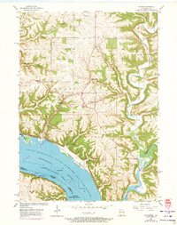
1957 Map of Potosi
USGS Topo · Published 1973About this map
The rugged bluff country of Grant County meets the winding waters of the Mississippi River in this detailed look at a historic lead-mining region. Significant mining activity is evidenced by a Mine and Quarry, while the town of Potosi stretches through narrow valleys toward its river landing at Potosi Station. This 1957 survey, updated with 1972 revisions, reveals the complex relationship between the steep driftless topography of Hog Hollow and Yankee Hollow and the vital transport corridors of the Burlington Northern and Chicago Milwaukee St Paul and Pacific railroads. The map captures the interface between industrial development and conservation within the Upper Mississippi River Wildlife and Fish Refuge, which encompasses Island 211 and Island 212. Local history and genealogy are well-represented by several burial grounds, including St Thomas Cem, Van Buren Cem, and Osceola Cem, alongside rural landmarks like the Rigsby Sch.
Find a feature on this map
37 named features on this map. Tap any name to fly to it.
Don’t see what you’re looking for? This feature index may not catch every label — zoom into the map to look around manually.
Map Details
Editions of this 1957 Potosi Map
2 editions found
Other maps of this area

1900 · Lancaster
USGS Topo · 1:125,000

1904 · Lancaster
USGS Topo · 1:125,000

1908 · Lancaster
USGS Topo · 1:125,000

1955 · Balltown
USGS Topo · 1:24,000

1956 · Dubuque North
USGS Topo · 1:24,000

1956 · Sherrill
USGS Topo · 1:24,000

1957 · Potosi
USGS Topo · 1:24,000

1959 · Dubuque
USGS Topo · 1:250,000

1961 · Dubuque
USGS Topo · 1:250,000
1961 · Dickeyville
USGS Topo · 1:24,000