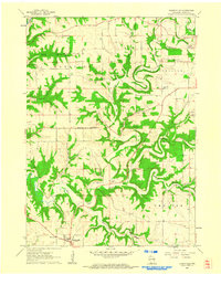
1961 Map of Dickeyville
USGS Topo · Published 1962About this map
Dickeyville and the surrounding rural townships of Harrison, Platteville, Paris, and Smelser define this early 1960s agricultural landscape in Grant County. The area's topography is heavily shaped by the winding course of the Little Platte River, which is fed by numerous tributaries including Blakely Branch, Roundtree Branch, and Blockhouse Creek. These waterways cut through the terrain, creating a series of wooded ridges and valleys that contrast with the cleared upland farms.
Find a feature on this map
29 named features on this map. Tap any name to fly to it.
Don’t see what you’re looking for? This feature index may not catch every label — zoom into the map to look around manually.
Map Details
Editions of this 1961 Dickeyville Map
3 editions found
Other maps of this area

1900 · Lancaster
USGS Topo · 1:125,000

1902 · Mineral Point
USGS Topo · 1:125,000

1904 · Lancaster
USGS Topo · 1:125,000

1908 · Lancaster
USGS Topo · 1:125,000

1952 · Platteville
USGS Topo · 1:24,000

1952 · Rewey
USGS Topo · 1:24,000

1952 · Cuba City
USGS Topo · 1:24,000

1956 · Dubuque North
USGS Topo · 1:24,000

1957 · Potosi
USGS Topo · 1:24,000

1959 · Dubuque
USGS Topo · 1:250,000