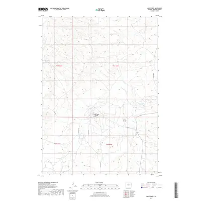
2017 Map of Lance Creek
USGS Topo · Published 2017About this map
West Lance Creek and the settlement of Lance Creek serve as the primary landmarks in this part of Niobrara County, situated where the high plains terrain is carved by a network of seasonal drainages. The landscape is defined by the convergence of several waterways, including Lance Cr and Little Lightning Cr, which dictate the local topography and the placement of rural infrastructure. A notable Water Storage Reservoir in the eastern section highlights the importance of water management in this arid region, while land use is further indicated by the presence of industrial and agricultural access routes like Carter Oil Co Rd and V S Hilltop Rd. The map also captures several distinct physical features, such as Twentymile Gulch in the northwest, which provide significant navigational markers for local history and geographic study.
Find a feature on this map
17 named features on this map. Tap any name to fly to it.
Don’t see what you’re looking for? This feature index may not catch every label — zoom into the map to look around manually.
Map Details
Editions of this 2017 Lance Creek Map
This is the sole edition of this map. No revisions or reprints were ever made.
Other maps of this area

1954 · Torrington
USGS Topo · 1:250,000

1955 · Newcastle
USGS Topo · 1:250,000

1958 · Torrington
USGS Topo · 1:250,000

1958 · Newcastle
USGS Topo · 1:250,000

1970 · Cooley Draw
USGS Topo · 1:24,000

1981 · Mercer Draw
USGS Topo · 1:24,000
1981 · Rabbit Mountains
USGS Topo · 1:24,000

1981 · Lance Creek NW
USGS Topo · 1:24,000
1981 · Funny Rock
USGS Topo · 1:24,000
1981 · Manville NE
USGS Topo · 1:24,000