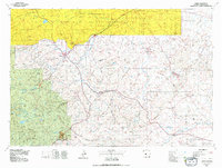
1978 Map of Lander
USGS Topo · Published 1979About this map
The Wind River Indian Reservation dominates the northern landscape of this 1970s survey, where the Little Wind River and Wind River converge. To the west, the high terrain of the Shoshone National Forest and Bridger National Forest gives way to the valley of Lander, the region's central hub. This map reveals a complex energy landscape, documenting numerous active extraction sites such as the Lander Hudson Oil Field, Dallas Oil Field, and the Sand Draw Oil and Gas Field. The industrial character of the era is further marked by the Columbia-Geneva Mines and the Chicago and North Western rail line. Historical movement across the Wyoming basin is preserved here through the charted paths of the Emigrant Trail and the Baldwin Trail, which navigate the prominent heights of the Beaver Divide and Beaver Rim.
Find a feature on this map
46 named features on this map. Tap any name to fly to it.
Don’t see what you’re looking for? This feature index may not catch every label — zoom into the map to look around manually.
Map Details
Editions of this 1978 Lander Map
2 editions found
Other maps of this area

1937 · Moccasin Lake
USGS Topo · 1:48,000

1943 · Moccasin Lake
USGS Topo · 1:62,500

1950 · Riverton East
USGS Topo · 1:24,000

1951 · Fuller Reservoir
USGS Topo · 1:24,000

1951 · Mule Butte
USGS Topo · 1:24,000

1951 · Indian Butte
USGS Topo · 1:24,000

1951 · Soap Holes
USGS Topo · 1:24,000

1951 · Pavillion SE
USGS Topo · 1:24,000

1951 · Fort Washakie
USGS Topo · 1:24,000

1951 · Riverton West
USGS Topo · 1:24,000