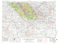
1955 Map of Lander
USGS Topo · Published 1983About this map
Lander and the southern reaches of the Wind River Range dominate this mid-century survey, which tracks the high-altitude transition across the Continental Divide. The map details the rugged intersection of the Wind River Indian Reservation and the vast Shoshone National Forest, reaching toward the prominent peaks of Square Top Mountain and Wind River Peak. Historical interest is anchored at the southern end of the range by South Pass City (Historical Site) and Atlantic City (Historical Site), remnants of early mining and migration routes. To the west, the landscape opens into the Great Divide Basin, featuring the Big Sandy Reservoir and the Boulder Weather Research Site AF near Pinedale. This edition reflects the mid-20th-century road network, including U.S. 287 and Wyoming 28, connecting the ranching and resource hubs of Hudson and Farson.
Find a feature on this map
70 named features on this map. Tap any name to fly to it.
Don’t see what you’re looking for? This feature index may not catch every label — zoom into the map to look around manually.
Map Details
Editions of this 1955 Lander Map
2 editions found

Other maps of this area

1907 · Gros Ventre
USGS Topo · 1:125,000

1909 · Fremont Peak
USGS Topo · 1:125,000

1910 · Gros Ventre
USGS Topo · 1:125,000

1937 · Moccasin Lake
USGS Topo · 1:48,000

1938 · Mt Bonneville
USGS Topo · 1:62,500

1939 · Big Piney
USGS Topo · 1:125,000

1941 · Mt Bonneville
USGS Topo · 1:62,500

1942 · Big Piney
USGS Topo · 1:125,000

1942 · Mt Bonneville
USGS Topo · 1:62,500

1943 · Moccasin Lake
USGS Topo · 1:62,500