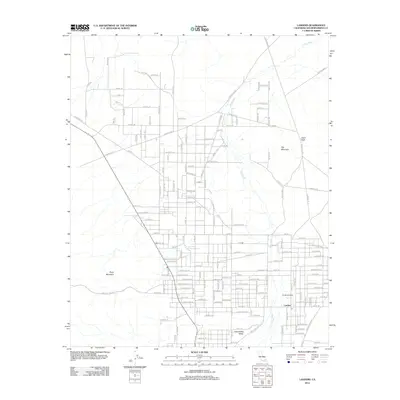
2012 Map of Landers
USGS Topo · Published 2012About this map
Landers and the neighboring community of Homestead Valley sit within a high desert landscape defined by ephemeral drainage systems and prominent geological outcrops. The most significant hydrological feature is Pipes Wash, which snakes through the eastern half of the area, while the surrounding terrain is marked by distinctive rises such as Spy Mountain, Ruby Mountain, and the notable Giant Rock. This 2012 survey illustrates the grid-based desert settlement patterns of the Morongo Basin, showing an extensive network of residential streets and trails that have developed around these natural landmarks. Local landmarks like the Po (Post Office) and the flat expanse of Coyote Flts characterize the spatial organization of this Mojave Desert community during the early 21st century.
Find a feature on this map
157 named features on this map. Tap any name to fly to it.
Don’t see what you’re looking for? This feature index may not catch every label — zoom into the map to look around manually.
Map Details
Editions of this 2012 Landers Map
This is the sole edition of this map. No revisions or reprints were ever made.
Other maps of this area

1901 · Southern California Sheet No. 1
USGS Topo · 1:250,000

1902 · San Gorgonio
USGS Topo · 1:125,000

1904 · Southern California Sheet No. 1
USGS Topo · 1:250,000

1953 · San Bernardino
USGS Topo · 1:250,000

1954 · Hidalgo Mtn
USGS Topo · 1:24,000

1954 · Emerson Lake
USGS Topo · 1:24,000

1955 · Goat Mountain
USGS Topo · 1:24,000

1955 · Old Woman Springs
USGS Topo · 1:62,500

1955 · Emerson Lake
USGS Topo · 1:62,500

1955 · Morongo Valley
USGS Topo · 1:62,500