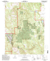
1993 Map of Lane Reservoir
USGS Topo · Published 1996About this map
Modoc National Forest encompasses much of this high-elevation landscape in northeastern California, where the terrain is defined by a series of flats and draws. The map illustrates a specialized water management network essential for ranching or forestry, featuring reservoirs like Lane Reservoir, Moll Reservoir, and Williams Reservoir. Small, isolated outposts such as Scotty Place and the Niles Cabin suggest a history of seasonal habitation or land management deep within the forest boundaries.
Find a feature on this map
31 named features on this map. Tap any name to fly to it.
Don’t see what you’re looking for? This feature index may not catch every label — zoom into the map to look around manually.
Map Details
Editions of this 1993 Lane Reservoir Map
This is the sole edition of this map. No revisions or reprints were ever made.
Other maps of this area

1886 · Alturas
USGS Topo · 1:250,000

1886 · Honey Lake
USGS Topo · 1:250,000

1891 · Honey Lake
USGS Topo · 1:250,000

1892 · Alturas
USGS Topo · 1:250,000

1893 · Honey Lake
USGS Topo · 1:250,000

1954 · Grasshopper Valley
USGS Topo · 1:62,500

1954 · Alturas
USGS Topo · 1:250,000

1955 · Westwood
USGS Topo · 1:250,000

1956 · Hayden Hill
USGS Topo · 1:62,500

1958 · Alturas
USGS Topo · 1:250,000