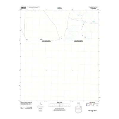
2010 Map of Lang Canyon
USGS Topo · Published 2010About this map
The international border between the United States and Mexico defines this high-desert landscape in the early 21st century. Isolated settlements and outposts like Garcia, Bramlett, and the Lang Ranch sit directly along the boundary line, highlighting the sparse but persistent human presence in this arid region. The eastern portion of the sheet is dominated by the foothills of the San Luis Mountains, where the namesake Lang Canyon provides a natural corridor through the rising terrain.
Find a feature on this map
9 named features on this map. Tap any name to fly to it.
Don’t see what you’re looking for? This feature index may not catch every label — zoom into the map to look around manually.
Map Details
Editions of this 2010 Lang Canyon Map
This is the sole edition of this map. No revisions or reprints were ever made.
Other maps of this area

1917 · Antelope Wells
USGS Topo · 1:62,500

1918 · Cienega Springs
USGS Topo · 1:62,500

1919 · Antelope Wells
USGS Topo · 1:62,500

1955 · Douglas
USGS Topo · 1:250,000

1959 · Douglas
USGS Topo · 1:250,000

1961 · Douglas
USGS Topo · 1:250,000

1964 · Douglas
USGS Topo · 1:250,000
1982 · Fitzpatricks
USGS Topo · 1:24,000
1982 · Black Point
USGS Topo · 1:24,000
1982 · San Luis Pass
USGS Topo · 1:24,000