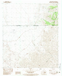
1983 Map of Lang Canyon
USGS Topo · Published 1983About this map
The Continental Divide winds through the high desert peaks of Hidalgo County in the early 1980s, marking a rugged intersection along the United States of America - Estados Unidos Mexicanos international border. This borderland landscape is defined by the San Luis Mountains and the Sierra San Luis, where deep drainage features like Lang Canyon and Cañon San Luis carve through the arid terrain. Human presence is tied to vital water sources such as Blackjack Tank and Larson Tank, which supported isolated settlements and outposts in this transborder region. Along the Mexican side of the line, small clusters like Los Lamentos, El Valle, and Agua Blanca appear as faint dots against the vast contours. The map captures a specific moment when these remote desert locations were documented through combined aerial photography and field checks, recording the topography of El Diablo and the southernmost reaches of New Mexico before modern shifts in regional infrastructure.
Find a feature on this map
23 named features on this map. Tap any name to fly to it.
Don’t see what you’re looking for? This feature index may not catch every label — zoom into the map to look around manually.
Map Details
Editions of this 1983 Lang Canyon Map
This is the sole edition of this map. No revisions or reprints were ever made.
Other maps of this area

1917 · Antelope Wells
USGS Topo · 1:62,500

1918 · Cienega Springs
USGS Topo · 1:62,500

1919 · Antelope Wells
USGS Topo · 1:62,500

1955 · Douglas
USGS Topo · 1:250,000

1959 · Douglas
USGS Topo · 1:250,000

1961 · Douglas
USGS Topo · 1:250,000

1964 · Douglas
USGS Topo · 1:250,000
1982 · Fitzpatricks
USGS Topo · 1:24,000
1982 · Black Point
USGS Topo · 1:24,000
1982 · San Luis Pass
USGS Topo · 1:24,000