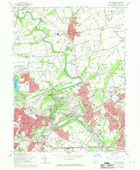
1966 Map of Langhorne
USGS Topo · Published 1968About this map
Neshaminy Creek winds through the heart of this landscape, separating the established boroughs of Newtown and Langhorne from the rapid mid-century suburban expansion to the south. This era shows the massive footprint of Levittown beginning to dominate the southeast, contrasting with the institutional grounds of the Eastern State Sch and Hosp and the Bucks County Community College. The map captures a high-speed chapter of local history with the Langhorne Speedway located near the Penn Central tracks and the Drive-in Theater. Older Quaker roots are still visible at the Middletown Meetinghouse, while the burgeoning transportation network is evidenced by the Pennsylvania Turnpike and the complex interchanges around Trevose. From the dense residential grids of Penndel to the open land near Woodside, the map documents a county in the midst of a significant residential and industrial transition.
Find a feature on this map
127 named features on this map. Tap any name to fly to it.
Don’t see what you’re looking for? This feature index may not catch every label — zoom into the map to look around manually.
Map Details
Editions of this 1966 Langhorne Map
2 editions found
Other maps of this area

1890 · Lambertville
USGS Topo · 1:62,500

1890 · Doylestown
USGS Topo · 1:62,500

1890 · Burlington
USGS Topo · 1:62,500

1891 · Lambertville
USGS Topo · 1:62,500

1891 · Doylestown
USGS Topo · 1:62,500

1893 · Germantown
USGS Topo · 1:62,500

1893 · Burlington
USGS Topo · 1:62,500

1894 · Lambertville
USGS Topo · 1:62,500

1894 · Germantown
USGS Topo · 1:62,500

1896 · Germantown
USGS Topo · 1:62,500
Featured Places
- Philadelphia, PA
- Bensalem Township, PA
- Middletown Township, PA
- Lower Makefield Township, PA
- Lower Southampton Township, PA