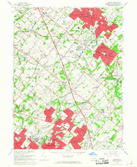
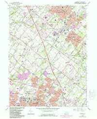
1966 Map of Lansdale
USGS Topo · Published 1968About this map
Norristown State Hospital anchors the southern edge of this mid-1960s landscape, illustrating the sprawling institutional footprint common in this part of Montgomery County. The region is defined by a dense network of suburban expansion and historic rural religious foundations, including the Schwenkfelder Cem and Towamencin Ch. Significant infrastructure projects such as the Pennsylvania Turnpike and several branches of the Reading railroad cut through established townships like Towamencin and Upper Gwynedd. This era shows the transition from smaller, independent settlements like Kulpsville and Center Square into a more continuous residential pattern. Local landmarks such as Wings Airport and Mermaid Lake appear alongside various schools and country clubs, reflecting the post-war recreational and educational development of the North Philadelphia suburbs.
Find a feature on this map
104 named features on this map. Tap any name to fly to it.
Don’t see what you’re looking for? This feature index may not catch every label — zoom into the map to look around manually.
Map Details
Editions of this 1966 Lansdale Map
5 editions found
Other maps of this area

1888 · Quakertown
USGS Topo · 1:62,500

1890 · Doylestown
USGS Topo · 1:62,500

1890 · Quakertown
USGS Topo · 1:62,500

1891 · Doylestown
USGS Topo · 1:62,500

1893 · Germantown
USGS Topo · 1:62,500

1894 · Quakertown
USGS Topo · 1:62,500

1894 · Norristown
USGS Topo · 1:62,500

1894 · Germantown
USGS Topo · 1:62,500

1895 · Norristown
USGS Topo · 1:62,500

1896 · Germantown
USGS Topo · 1:62,500