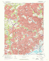
1967 Map of Lansdowne
USGS Topo · Published 1974About this map
Darby Creek and Cobbs Creek carve a natural drainage through this intensely developed landscape on the western edge of Philadelphia. This late-1960s survey documents the post-war suburban densification of eastern Delaware County, where once-separate boroughs like Lansdowne, Darby, and Yeadon merged into a continuous urban corridor. Large-scale institutional land use is a defining characteristic of the area, evidenced by the sprawling grounds of Swarthmore College and the St. Charles Borromeo Seminary.
Find a feature on this map
160 named features on this map. Tap any name to fly to it.
Don’t see what you’re looking for? This feature index may not catch every label — zoom into the map to look around manually.
Map Details
Editions of this 1967 Lansdowne Map
4 editions found
Other maps of this area

1891 · Philadelphia
USGS Topo · 1:62,500

1893 · Germantown
USGS Topo · 1:62,500

1894 · Chester
USGS Topo · 1:62,500

1894 · Philadelphia
USGS Topo · 1:62,500

1894 · Norristown
USGS Topo · 1:62,500

1894 · Germantown
USGS Topo · 1:62,500

1895 · Norristown
USGS Topo · 1:62,500

1896 · Germantown
USGS Topo · 1:62,500

1896 · Philadelphia
USGS Topo · 1:62,500

1896 · Norristown
USGS Topo · 1:62,500