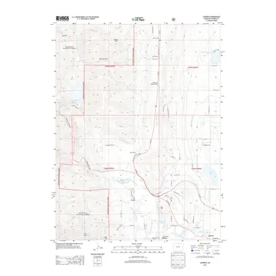
2013 Map of Laporte
USGS Topo · Published 2013About this map
The Cache la Poudre River and its complex network of irrigation infrastructure define this Larimer County landscape. Settled at the foot of the Roosevelt National Forest, the communities of Bellvue and Laporte are surrounded by a legacy of water management visible in the Munroe Gravity Canal, Poudre Valley Canal, and Charles Hansen Canal. These engineering feats, alongside the Little Cache la Poudre Ditch, sustained the agricultural operations of family-named holdings like McMurry Ranch and Kramer Ranch. The terrain transitions from the high peaks of Bonner Peak and Cloudy Pass down into the narrow corridors of Log Canyon and Rist Canyon. Conservation and utility are paired here, with the Bellvue State Fish Hatchery sitting just south of Watson Lake, while the Milton Seaman Reservoir captures the flow of the North Fork Cache La Poudre River as it enters the valley.
Find a feature on this map
71 named features on this map. Tap any name to fly to it.
Don’t see what you’re looking for? This feature index may not catch every label — zoom into the map to look around manually.
Map Details
Editions of this 2013 Laporte Map
This is the sole edition of this map. No revisions or reprints were ever made.
Other maps of this area

1906 · Fort Collins
USGS Topo · 1:62,500

1907 · Livermore
USGS Topo · 1:125,000

1908 · Fort Collins
USGS Topo · 1:62,500

1909 · Livermore
USGS Topo · 1:125,000

1954 · Greeley
USGS Topo · 1:250,000

1957 · Greeley
USGS Topo · 1:250,000

1958 · Greeley
USGS Topo · 1:250,000

1960 · Livermore
USGS Topo · 1:24,000
1960 · Fort Collins
USGS Topo · 1:24,000
1960 · Buckeye
USGS Topo · 1:24,000