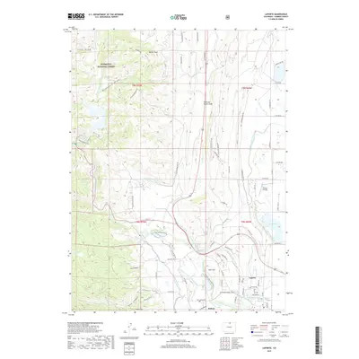
2019 Map of Laporte
USGS Topo · Published 2019About this map
The Cache la Poudre River and its North Fork define the drainage of this area at the eastern edge of the Roosevelt National Forest. The landscape is characterized by a complex irrigation network essential to the agricultural development of Larimer County, featuring the Munroe-Gravity Canal, Poudre Valley Canal, and Charles Hansen Canal. Near the settlements of Laporte and Bellvue, the water management system is particularly dense, with the Larimer-County Canal and Little Cache la Poudre Ditch diverting water across the valley floor. Higher elevations to the west are marked by rugged features such as Bonner Peak and the southern reach of Obenchain Draw. This modern survey documents the contemporary interface between the protected forest lands and the developed plains, including landmarks like the Kellogg Airstrip and specialized infrastructure like the Old Feldspar Mine Rd.
Find a feature on this map
74 named features on this map. Tap any name to fly to it.
Don’t see what you’re looking for? This feature index may not catch every label — zoom into the map to look around manually.
Map Details
Editions of this 2019 Laporte Map
This is the sole edition of this map. No revisions or reprints were ever made.
Other maps of this area

1906 · Fort Collins
USGS Topo · 1:62,500

1907 · Livermore
USGS Topo · 1:125,000

1908 · Fort Collins
USGS Topo · 1:62,500

1909 · Livermore
USGS Topo · 1:125,000

1954 · Greeley
USGS Topo · 1:250,000

1957 · Greeley
USGS Topo · 1:250,000

1958 · Greeley
USGS Topo · 1:250,000

1960 · Livermore
USGS Topo · 1:24,000
1960 · Fort Collins
USGS Topo · 1:24,000
1960 · Buckeye
USGS Topo · 1:24,000