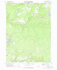
1969 Map of LaPorte
USGS Topo · Published 1977About this map
Loyalsock Creek winds through the heart of this late-1960s landscape, a region defined by its transition from industrial extraction to forest conservation. Evidence of the area's coal heritage is visible near Mildred and Bernice, where numerous Strip Mines scar the hillsides. These industrial sites contrast with the developed recreation at Lake Mokoma and the remote reaches of Wyoming State Forest.
Find a feature on this map
58 named features on this map. Tap any name to fly to it.
Don’t see what you’re looking for? This feature index may not catch every label — zoom into the map to look around manually.
Map Details
Editions of this 1969 LaPorte Map
Other maps of this area

1927 · Eagles Mere
USGS Topo · 1:48,000

1932 · Eagle Mere
USGS Topo · 1:62,500

1934 · Laporte
USGS Topo · 1:62,500

1943 · Monroeton
USGS Topo · 1:62,500

1943 · Powell
USGS Topo · 1:62,500

1945 · Powell
USGS Topo · 1:62,500

1953 · LaPorte
USGS Topo · 1:62,500

1953 · Eagles Mere
USGS Topo · 1:62,500

1954 · Williamsport
USGS Topo · 1:250,000

1960 · Williamsport
USGS Topo · 1:250,000
Featured Places
- Laporte, PA
- Davidson Township, PA
- Nordmont, Laporte Township
- Ringdale, Laporte Township
- Bernice, Cherry Township