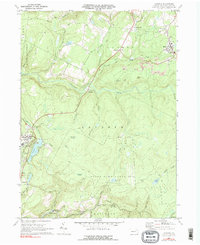
1969 Map of LaPorte
USGS Topo · Published 1981About this map
The town of Laporte serves as a central hub on this Sullivan County landscape, where the Laporte High Sch and Lake Mokoma anchor the local community. To the northeast, the coal-mining heritage of the region is evident near Bernice and Mildred, where multiple Strip Mine operations and gravel pits mark the terrain. The presence of the Lehigh Valley Railroad and the Birch Grade Railroad highlights the industrial transport network that once moved timber and anthracite through these highlands.
Find a feature on this map
41 named features on this map. Tap any name to fly to it.
Don’t see what you’re looking for? This feature index may not catch every label — zoom into the map to look around manually.
Map Details
Editions of this 1969 LaPorte Map
Other maps of this area

1927 · Eagles Mere
USGS Topo · 1:48,000

1932 · Eagle Mere
USGS Topo · 1:62,500

1934 · Laporte
USGS Topo · 1:62,500

1943 · Monroeton
USGS Topo · 1:62,500

1943 · Powell
USGS Topo · 1:62,500

1945 · Powell
USGS Topo · 1:62,500

1953 · LaPorte
USGS Topo · 1:62,500

1953 · Eagles Mere
USGS Topo · 1:62,500

1954 · Williamsport
USGS Topo · 1:250,000

1960 · Williamsport
USGS Topo · 1:250,000
Featured Places
- Laporte, PA
- Davidson Township, PA
- Nordmont, Laporte Township
- Ringdale, Laporte Township
- Bernice, Cherry Township