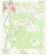
1979 Map of Laredo South
USGS Topo · Published 1980About this map
The international border defined by the Rio Bravo Grande anchors this 1970s topographic study, illustrating the binational expansion of Laredo and Nuevo Laredo. While the urban core of Laredo shows dense development around the Nat Guard Armory and the Daiches Sch, the southern periphery reveals a network of rural settlements and agricultural interests. Small outposts such as Santa Maria (Angelica), Las Carmelitas, and La Cooperativa line the transportation corridors leading away from the river. The landscape is carved by several major drainages, including Chacon Creek and San Idelfonso Creek, which flow toward the Rio Grande. Further east, the terrain transitions into more industrial and utility-focused uses, evidenced by Gravel Pits and various landing strips and pipelines that supported the regional economy of South Texas during this period.
Find a feature on this map
27 named features on this map. Tap any name to fly to it.
Don’t see what you’re looking for? This feature index may not catch every label — zoom into the map to look around manually.
Map Details
Editions of this 1979 Laredo South Map
2 editions found
Other maps of this area

1933 · Becerra Creek
USGS Topo · 1:62,500

1956 · Islitas
USGS Topo · 1:62,500

1956 · Laredo East
USGS Topo · 1:62,500

1956 · Laredo
USGS Topo · 1:250,000

1965 · Laredo West
USGS Topo · 1:24,000

1965 · Tios Creek
USGS Topo · 1:24,000

1965 · Laredo East
USGS Topo · 1:24,000
1979 · Isla Mesteno
USGS Topo · 1:24,000

1979 · Laredo South
USGS Topo · 1:24,000

1979 · O'Keefe Lake
USGS Topo · 1:24,000
Featured Places
- Laredo, TX
- La Presa, TX
- Tanquecitos South Acres Colonia, TX
- Larga Vista, Laredo
- Old Milwaukee West Colonia, TX