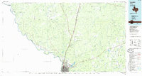
1985 Map of Laredo
USGS Topo · Published 1985About this map
The Rio Grande defines the international boundary and the character of this South Texas landscape, where the growing urban center of Laredo meets the vast ranchlands of Webb County. In the mid-1980s, the city’s expansion is evident through the development of Del Mar and the infrastructure at Laredo International Airport, while the surrounding terrain remains dominated by intricate drainage systems like Arroyo Sombrerito and Arroyo Blanco. The map captures a critical transportation hub where the Missouri Pacific and Texas Mexican railroads converge, supporting the region's cross-border commerce.
Find a feature on this map
58 named features on this map. Tap any name to fly to it.
Don’t see what you’re looking for? This feature index may not catch every label — zoom into the map to look around manually.
Map Details
Editions of this 1985 Laredo Map
3 editions found
Other maps of this area

1923 · Palafox
USGS Topo · 1:62,500

1929 · Cotulla
USGS Topo · 1:125,000

1933 · Becerra Creek
USGS Topo · 1:62,500

1937 · Aguilete Creek
USGS Topo · 1:62,500

1939 · Bruni
USGS Topo · 1:62,500

1940 · Aguilares
USGS Topo · 1:62,500

1940 · Velenzuela Creek
USGS Topo · 1:62,500

1940 · San Loranzo Creek
USGS Topo · 1:62,500

1940 · Chupadera
USGS Topo · 1:62,500

1953 · Crystal City
USGS Topo · 1:250,000