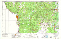
1956 Map of Laredo
USGS Topo · Published 1979About this map
Laredo serves as the focal point of this South Texas landscape, marking a vital international crossroads along the Mexico United States border. The 1970s revision captures a region defined by extensive ranchlands and a sophisticated transportation network, where the Texas Mexican RR and Missouri Pacific RR cut through the brush country to connect inland hubs like Hebbronville and Alice. The map reveals the early footprint of regional energy and water infrastructure, from the expansive Falcon Reservoir on the Rio Grande to the cluster of oil-field settlements including Oilton, Bruni, and Mirando City.
Find a feature on this map
52 named features on this map. Tap any name to fly to it.
Don’t see what you’re looking for? This feature index may not catch every label — zoom into the map to look around manually.
Map Details
Editions of this 1956 Laredo Map
3 editions found

Other maps of this area

1917 · Ben Bolt
USGS Topo · 1:62,500

1920 · Mikeska
USGS Topo · 1:125,000

1920 · San Diego
USGS Topo · 1:62,500

1921 · Falfurrias
USGS Topo · 1:125,000

1923 · Armstrong
USGS Topo · 1:62,500

1923 · Palafox
USGS Topo · 1:62,500

1925 · Mathis No. 3
USGS Topo · 1:48,000

1927 · Mathis
USGS Topo · 1:62,500

1928 · Sarita
USGS Topo · 1:125,000

1929 · Cotulla
USGS Topo · 1:125,000