Loading...
Loading map...1956 Map of Laredo
USGS Topo · Published 1968About this map
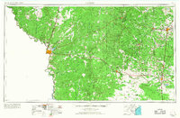
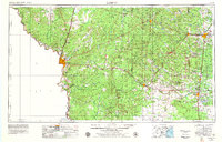
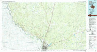
The Rio Grande marks the international boundary between the United States and Mexico in this mid-century survey of the South Texas brush country. The urban center of Laredo is anchored by the Laredo Air Force Base, while the surrounding landscape is defined by an extensive network of petroleum extraction. Numerous symbols for Oil Fields and an underground pipeline illustrate the industrial character of Webb County and Duval County during this era of intensive energy development.
Find a feature on this map
58 named features on this map. Tap any name to fly to it.
Don’t see what you’re looking for? This feature index may not catch every label — zoom into the map to look around manually.
Map Details
Date Portrayed1956
Date Published1968
PublisherU.S. Geological Survey
Map TypeTopographic
Scale1:250,000
Physical Dimensions33.5 x 22 inches
Editions of this 1956 Laredo Map
3 editions found

Historical Maps of Falfurrias Through Time
Featured Locations
Source Details
SourceU.S. Geological Survey
CopyrightPublic Domain