1985 Map of Laredo
USGS Topo · Published 1993About this map
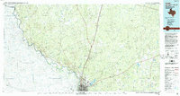
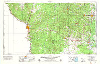
The Rio Grande carves a winding path through the brushlands of Webb County, defining the international border between Laredo and Nuevo Laredo during the mid-1980s. This regional survey captures the transition from the dense urban centers of the border cities to the sprawling ranchlands and arroyos of south Texas. The transportation network is dominated by the Missouri Pacific railroad and a series of smaller sidings and settlements like Cactus, Webb, and Botines that follow the rail line north. On the eastern edge of the city, Lake Casa Blanca and Laredo International Airport mark the expanding footprint of the community. Beyond the city limits, the landscape is a complex web of seasonal drainages, including Arroyo Pescadito and Chacon Creek, interspersed with prominent high points such as Big Apache Hill and Loma Blanca.
Find a feature on this map
53 named features on this map. Tap any name to fly to it.
Don’t see what you’re looking for? This feature index may not catch every label — zoom into the map to look around manually.
Map Details
Editions of this 1985 Laredo Map
3 editions found