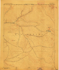
1895 Map of Largo
USGS Topo · Published 1911About this map
Bloomfield and the small settlement of Largo anchor the northwest corner of this late-19th-century reconnaissance, where the San Juan River meets the Animas River and Los Pinos River. The landscape of northern Rio Arriba is defined by an intricate network of deep drainages, including the expansive Gobernador Canyon and Blanco Canyon, which reveal the complex topography encountered by early surveyors like W.W. Davis and Hayden. To the east, the terrain shifts toward high-altitude hydrology at Horse Lake and the nearby Stinking Lakes, which feed into mysterious Sinks. These features, alongside isolated landmarks such as Angels Peak and El Huerfano, provide a rare record of the territory just south of the Colorado New Mexico Boundary Line during the territorial era. The map traces early routes and water sources like Mud Spring that were vital for transit through these high desert canyons before modern infrastructure arrived.
Find a feature on this map
25 named features on this map. Tap any name to fly to it.
Don’t see what you’re looking for? This feature index may not catch every label — zoom into the map to look around manually.
Map Details
Editions of this 1895 Largo Map
3 editions found

Other maps of this area

1883 · Mt. Taylor
USGS Topo · 1:250,000

1886 · Wingate
USGS Topo · 1:250,000

1886 · Mt. Taylor
USGS Topo · 1:250,000

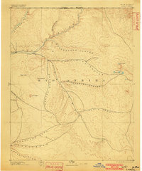
1889 · Largo
USGS Topo · 1:250,000

1889 · Chaco
USGS Topo · 1:250,000

1890 · Jemes
USGS Topo · 1:125,000

1892 · Jemes
USGS Topo · 1:125,000

1892 · Wingate
USGS Topo · 1:250,000

1892 · Chaco
USGS Topo · 1:250,000

1892 · Mt. Taylor
USGS Topo · 1:250,000