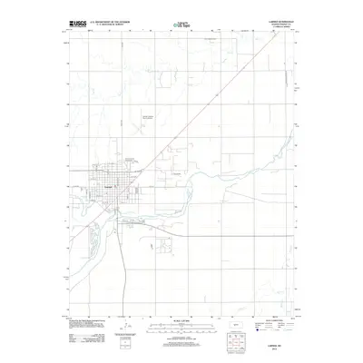
2012 Map of Larned
USGS Topo · Published 2012About this map
The confluence of the Pawnee River and the Arkansas River defines the landscape of this Kansas plains settlement. The town of Larned serves as the central hub, organized on a grid featuring major thoroughfares like S Main St and Broadway St, with the local Po situated in the heart of the community. The surrounding countryside reflects a dual economy of agriculture and energy production, evidenced by the Ash Creek Oil Field and the Larned Oil Field located just outside the residential areas. Transportation infrastructure is prominent, with the Larned- Pawnee County Airport north of town and a network of county roads including Toles Rd and NE Trail Rd. Waterways such as Ash Cr, Pickle Cr, and Hubbard Cr carve through the prairie, illustrating the drainage patterns vital to the region's development and irrigation.
Find a feature on this map
35 named features on this map. Tap any name to fly to it.
Don’t see what you’re looking for? This feature index may not catch every label — zoom into the map to look around manually.
Map Details
Editions of this 2012 Larned Map
This is the sole edition of this map. No revisions or reprints were ever made.
Other maps of this area

1889 · Larned
USGS Topo · 1:125,000

1891 · Great Bend
USGS Topo · 1:125,000

1891 · Larned
USGS Topo · 1:125,000

1893 · Great Bend
USGS Topo · 1:125,000

1955 · Great Bend
USGS Topo · 1:250,000

1957 · Great Bend
USGS Topo · 1:250,000

1958 · Great Bend
USGS Topo · 1:250,000

1960 · Pawnee Rock
USGS Topo · 1:24,000
1969 · Radium
USGS Topo · 1:24,000

1970 · Fort Larned
USGS Topo · 1:24,000