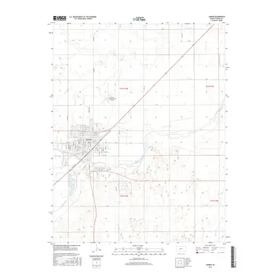
2015 Map of Larned
USGS Topo · Published 2015About this map
Larned sits at a significant geographic junction where the Pawnee River meets the Arkansas River, a confluence that has historically defined the region's development and water management. This 2015 survey illustrates the modern layout of the city, showing a structured grid of residential and commercial streets such as Broadway Ave and W 14th St. North of the urban center, the Larned-Pawnee County Airport serves as a modern transportation hub for the county. The surrounding landscape is characterized by the meandering paths of Ash Cr, Pickle Cr, and Hubbard Cr, which drain the agricultural plains surrounding the settlement. The map provides clear evidence of the section-line road system, including routes like Toles Rd and 90th Ave, that organizes the rural landscape into productive blocks.
Find a feature on this map
66 named features on this map. Tap any name to fly to it.
Don’t see what you’re looking for? This feature index may not catch every label — zoom into the map to look around manually.
Map Details
Editions of this 2015 Larned Map
This is the sole edition of this map. No revisions or reprints were ever made.
Other maps of this area

1889 · Larned
USGS Topo · 1:125,000

1891 · Great Bend
USGS Topo · 1:125,000

1891 · Larned
USGS Topo · 1:125,000

1893 · Great Bend
USGS Topo · 1:125,000

1955 · Great Bend
USGS Topo · 1:250,000

1957 · Great Bend
USGS Topo · 1:250,000

1958 · Great Bend
USGS Topo · 1:250,000

1960 · Pawnee Rock
USGS Topo · 1:24,000
1969 · Radium
USGS Topo · 1:24,000

1970 · Fort Larned
USGS Topo · 1:24,000