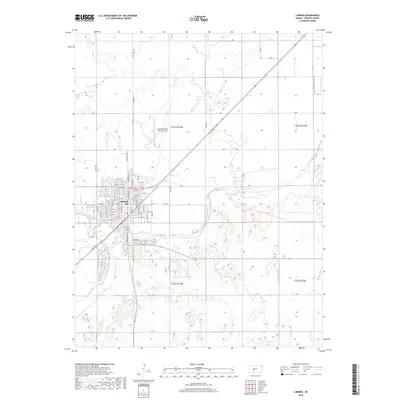
2018 Map of Larned
USGS Topo · Published 2018About this map
Larned stands at the confluence of the Arkansas River and Ash Cr, serving as a significant agricultural and transportation hub in Pawnee County. The town's grid is well-established, featuring a dense network of streets such as Broadway Ave, W 17th St, and Tera Cir. Transportation infrastructure is a defining characteristic of this landscape, with a railroad Spur serving local industry and the Larned-Pawnee County Airport positioned to the north. Beyond the town limits, the terrain is defined by a systematic section line road grid, including Toles Rd and 90th Ave, which carve through the plains. Natural drainage patterns are evident through the meandering paths of Pickle Cr and Hubbard Cr to the southeast, highlighting the transition from the concentrated urban center to the wide-open prairie used for Kansas farming.
Find a feature on this map
71 named features on this map. Tap any name to fly to it.
Don’t see what you’re looking for? This feature index may not catch every label — zoom into the map to look around manually.
Map Details
Editions of this 2018 Larned Map
This is the sole edition of this map. No revisions or reprints were ever made.
Other maps of this area

1889 · Larned
USGS Topo · 1:125,000

1891 · Great Bend
USGS Topo · 1:125,000

1891 · Larned
USGS Topo · 1:125,000

1893 · Great Bend
USGS Topo · 1:125,000

1955 · Great Bend
USGS Topo · 1:250,000

1957 · Great Bend
USGS Topo · 1:250,000

1958 · Great Bend
USGS Topo · 1:250,000

1960 · Pawnee Rock
USGS Topo · 1:24,000
1969 · Radium
USGS Topo · 1:24,000

1970 · Fort Larned
USGS Topo · 1:24,000