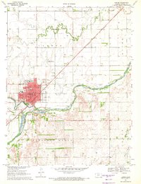
1970 Map of Larned
USGS Topo · Published 1972About this map
Larned serves as the focal point of this 1970s survey, situated at the confluence of the Pawnee River and the Arkansas River. The town's grid is dense with civic and social infrastructure, including several educational institutions such as Sacred Heart Sch, Northside Sch, and Phinney Sch. To the north, the Larned-Pawnee County Airport and the Ash Valley Grange Hall reflect the region's agricultural and transportation priorities.
Find a feature on this map
33 named features on this map. Tap any name to fly to it.
Don’t see what you’re looking for? This feature index may not catch every label — zoom into the map to look around manually.
Map Details
Editions of this 1970 Larned Map
This is the sole edition of this map. No revisions or reprints were ever made.
Other maps of this area

1889 · Larned
USGS Topo · 1:125,000

1891 · Great Bend
USGS Topo · 1:125,000

1891 · Larned
USGS Topo · 1:125,000

1893 · Great Bend
USGS Topo · 1:125,000

1955 · Great Bend
USGS Topo · 1:250,000

1957 · Great Bend
USGS Topo · 1:250,000

1958 · Great Bend
USGS Topo · 1:250,000

1960 · Pawnee Rock
USGS Topo · 1:24,000
1969 · Radium
USGS Topo · 1:24,000

1970 · Fort Larned
USGS Topo · 1:24,000