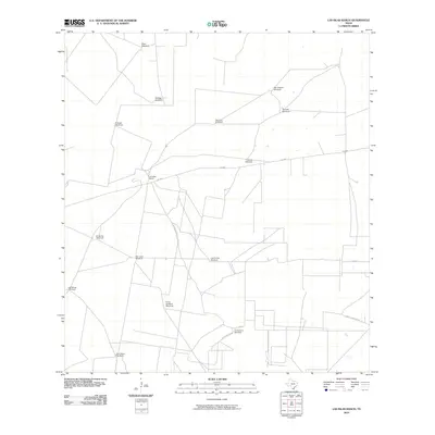
2010 Map of Las Islas Ranch
USGS Topo · Published 2010About this map
Las Islas Ranch serves as the central point of reference in this ranching landscape of Starr County, Texas. The region is defined by a sparse network of roads like FM 2686 and an extensive infrastructure of named water sources. Wind-powered wells are the lifeblood of this arid terrain, with numerous family and place-named landmarks including Brazil Windmill, Borrego Windmill, and San Antonio Windmill distributed across the landscape. The reliance on these features underscores the historical and ongoing importance of groundwater for livestock in the Brush Country.
Find a feature on this map
18 named features on this map. Tap any name to fly to it.
Don’t see what you’re looking for? This feature index may not catch every label — zoom into the map to look around manually.
Map Details
Editions of this 2010 Las Islas Ranch Map
This is the sole edition of this map. No revisions or reprints were ever made.
Other maps of this area

1938 · El Sauz
USGS Topo · 1:62,500

1938 · Agua Nueva
USGS Topo · 1:62,500

1938 · Sal Colorada
USGS Topo · 1:62,500

1938 · Cuevitas
USGS Topo · 1:62,500

1949 · Mc Allen
USGS Topo · 1:250,000

1954 · McAllen
USGS Topo · 1:250,000

1957 · Mc Allen
USGS Topo · 1:250,000

1962 · McAllen
USGS Topo · 1:250,000

1972 · Cuevitas
USGS Topo · 1:24,000
1972 · Viboras
USGS Topo · 1:24,000