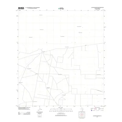
2012 Map of Las Islas Ranch
USGS Topo · Published 2012About this map
Las Islas Ranch serves as the central landmark for this arid section of South Texas, where the landscape is defined by a sparse but critical network of water infrastructure. The territory is marked by numerous family-named and descriptive water sources, including the Brazil Windmill, Borrego Windmill, and San Antonio Windmill, reflecting the ranching heritage of the Rio Grande Valley. These points of extraction were essential for sustaining livestock in a region where surface water is scarce. Transportation is limited to a few arterial routes such as FM-2686 and local tracks like Rancho San Blas Rd, which connect the isolated ranching operations. The distribution of sites like La Purisma Windmill and Cinca de Mayo Windmill across the grid indicates the deliberate planning required to manage vast tracts of rangeland in Starr County.
Find a feature on this map
18 named features on this map. Tap any name to fly to it.
Don’t see what you’re looking for? This feature index may not catch every label — zoom into the map to look around manually.
Map Details
Editions of this 2012 Las Islas Ranch Map
This is the sole edition of this map. No revisions or reprints were ever made.
Other maps of this area

1938 · El Sauz
USGS Topo · 1:62,500

1938 · Agua Nueva
USGS Topo · 1:62,500

1938 · Sal Colorada
USGS Topo · 1:62,500

1938 · Cuevitas
USGS Topo · 1:62,500

1949 · Mc Allen
USGS Topo · 1:250,000

1954 · McAllen
USGS Topo · 1:250,000

1957 · Mc Allen
USGS Topo · 1:250,000

1962 · McAllen
USGS Topo · 1:250,000

1972 · Cuevitas
USGS Topo · 1:24,000
1972 · Viboras
USGS Topo · 1:24,000